Is This Noah’s Ark? What the 2026 Durupınar Fieldwork Has and Hasn’t Shown
Team Ilm Ora · 15 October 2026
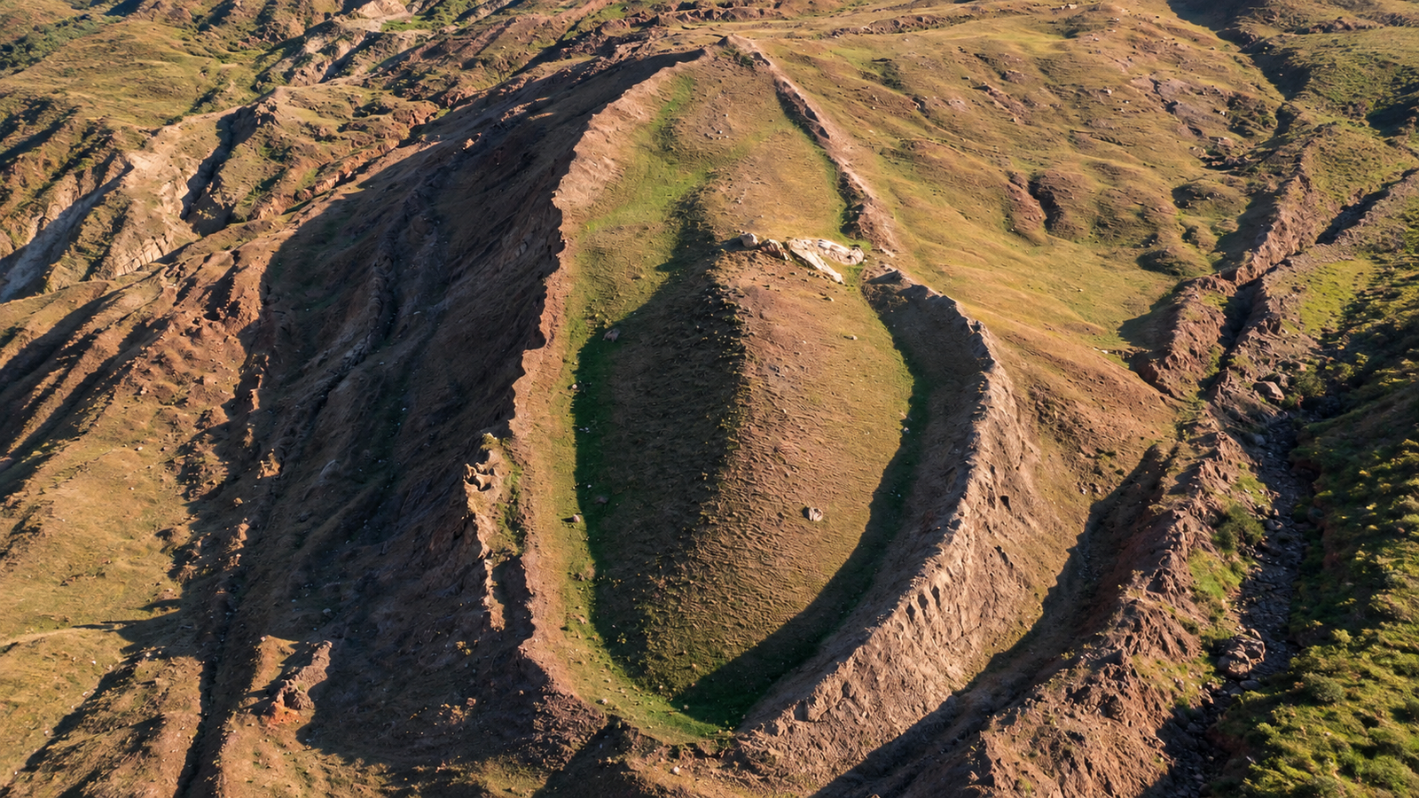
In the rugged terrain of eastern Turkey, roughly thirty kilometers south of Mount Ararat, lies a striking geological feature known as the Durupınar formation. Resembling the massive, symmetrical hull of a ocean-going vessel embedded in the earth, this site has captivated explorers, scientists, and religious scholars for over half a century. In mid-2026, an international research team completed the most extensive field investigation in the site's history, recovering deep core samples and conducting advanced subsurface radar scans. Sensational headlines quickly declared that Noah’s Ark had been definitively discovered. However, moving past the media frenzy requires examining what subsurface imaging tools can actually detect, how geomorphology shapes our landscape, and what authentic Islamic tradition precisely teaches regarding the vessel of Nuh (peace be upon him).
The Geology of a Mythic Outline
The shape that has sparked decades of debate is a 157-meter-long earthen mound shaped remarkably like a ship's bow and stern. First noticed in 1959 by Turkish army captain İlhan Durupınar while reviewing NATO aerial surveillance photographs, the site immediately drew international interest. To the untrained eye, the crisp, pointed perimeter appears far too deliberate to be a mere accident of nature. However, earth scientists categorize the site within the framework of slope dynamics and structural geology. The formation sits within an active earthflow zone—a process where saturated, fine-grained soil and weathered rock move slowly downhill under the force of gravity.
When flowing mud and debris encounter a resistant, immobile block of hard bedrock submerged beneath the surface, the soft material is forced to flow around both sides of the obstruction. This hydro-geological interaction naturally creates an elongated, tear-drop ridge with tapered ends, mirroring fluid dynamics seen in ship hull design. What appears to be an artificial structure crafted by human hands is, in classic geological terms, an erosion-resistant kink band formed by regional tectonic pressure and localized soil movements. Understanding this natural mechanism is essential before evaluating any claims of artificial origin.
Decoding Subsurface Probing and Radiocarbon Testing
The 2026 expedition, led by archeologists from Sivas Cumhuriyet University alongside international researchers, brought modern analytical tools to the site. Ground-penetrating radar, or GPR, works by transmitting high-frequency electromagnetic radio pulses into the soil. When these waves encounter a boundary between two materials with differing electrical properties—such as soft clay meeting hard basalt rock, or dense soil meeting a hollow void—a portion of the wave bounces back to a receiver on the surface. While public reports highlighted rectangular patterns and right-angle echoes in the radar data, geophysicists point out that subsurface rock strata routinely fracture along linear, orthogonal joint lines due to tectonic strain. Straight lines underground are a common feature of natural geology and do not automatically indicate human timber construction. Similarly, soil core samples pulled from deep within the formation revealed elevated organic carbon concentrations compared to surrounding surface soil. Organic carbon measures the amount of carbon tied up in organic matter, such as decayed plant roots, ancient peat deposits, or petroleum-bearing shale. While a petrified wooden hull would indeed increase carbon readings, so would a localized pocket of prehistoric vegetation buried under ancient landslide debris. To verify the origin of these organic molecules, scientists rely on radiocarbon dating, a technique that measures the decay of carbon-14 isotopes. Because living plants continually absorb carbon-14 from the atmosphere until they die, measuring the remaining unstable isotope allows scientists to calculate exactly when the organism stopped living. Until these carbon samples undergo rigorous, peer-reviewed laboratory testing to confirm whether the material is fossilized wood tissue rather than geological shale, claims of a wooden structure remain unproven assertions.
The Biblical Cubit and the Quranic Horizon
Much of the popular fascination with the Durupınar formation stems from its physical length, which proponents claim aligns with ancient descriptions of the vessel. In the Judeo-Christian tradition, the Book of Genesis records the dimensions of the Ark as three hundred cubits long. A cubit was an ancient unit of measurement based on the distance from an adult's elbow to the tip of the middle finger. Because human bodies vary, historical cubits differed across civilizations: the common Hebrew cubit measured roughly 45 centimeters, whereas the Egyptian royal cubit measured approximately 52.4 centimeters. By selecting specific regional cubit definitions, commentators can stretch or shrink the calculated length of the Biblical Ark between 135 meters and 162 meters, allowing the 157-meter Durupınar site to appear as a precise fit. In contrast, the Quran provides a distinct theological framework that avoids geometric specifications while emphasizing spiritual lessons. Islamic tradition makes no mention of the Ark's precise length, width, or structural tonnage, focusing instead on the divine command given to Nuh (peace be upon him) to construct the vessel under divine guidance. Furthermore, the Quranic narrative specifies a different geographical destination for the landing site. Surah Hud (11:44) explicitly states that after the floodwaters receded, the vessel came to rest upon al-Judi. Historically, classical Muslim geographers, exegetes, and historians located Mount Judi (Jabal Judi) near the modern city of Cizre in southeastern Turkey—a location over two hundred kilometers south of Mount Ararat and the Durupınar formation. Conflating the Biblical tradition of "the mountains of Ararat" with the specific Quranic landmark of Mount Judi overlooks centuries of geography and textual scholarship.
Epistemology, Sacred History, and Scientific Rigor
The search for historical remnants of sacred events often creates a tension between empirical science and religious devotion. In Islamic epistemology, foundational historical events such as the Flood and the Ark of Nuh are affirmed through authentic revelation (wahi), not contingent upon physical archeological discovery. Creating false equivalencies between unverified soil anomalies and sacred history risks undermining public confidence when geological analyses inevitably favor natural explanations. True scientific investigation requires patience, allowing core samples, petrographic microscopic analyses, and peer-reviewed geological surveys to proceed without the pressure of sensational headlines. As laboratory analyses of the 2026 core samples continue through the coming months, the broader scientific community remains cautious. The study of the earth reveals that nature is fully capable of carving symmetrical, ship-like formations across mountain slopes over thousands of years of erosion. Whether the Durupınar ridge is ultimately confirmed as a unique geological anomaly or a site of ancient human activity, the narrative of resilience, faith, and renewal embodied in the history of Prophet Nuh remains entirely independent of a drill bit in the dirt.
Faith in divine history does not require a piece of petrified wood to validate it, and true science never rushes to claim as fact what the earth has yet to reveal.